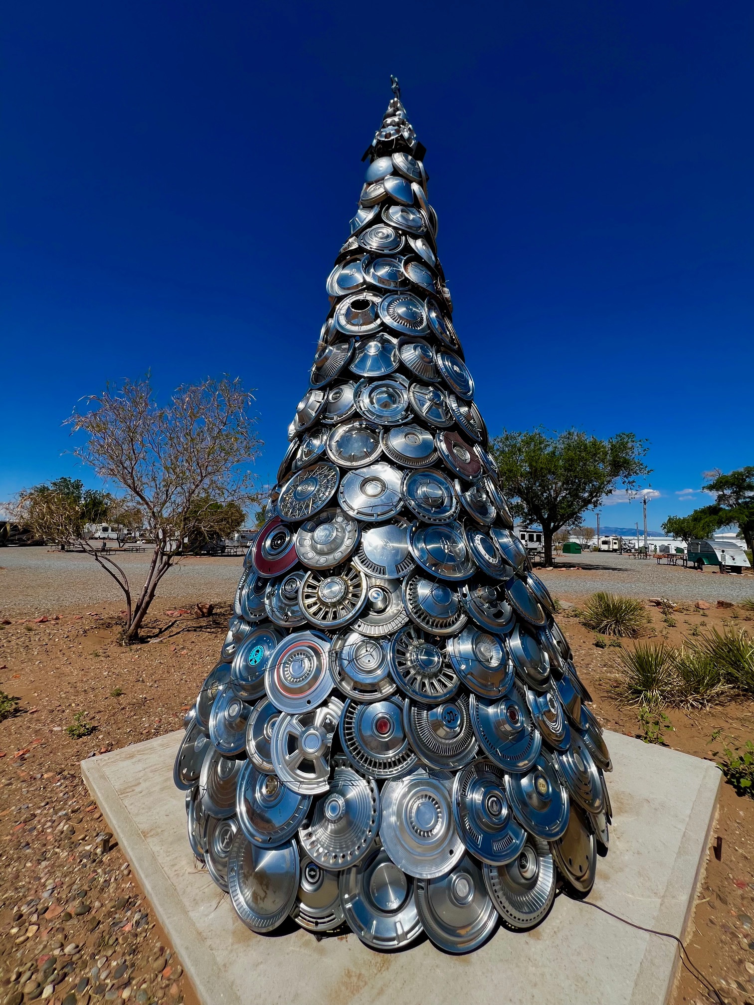
This 17 foot stunning tree of pure metal boasts of over 300 hubcaps secured to a steel frame. Enchanted Trails owner Vickie Ashcraft’s dream came to fruition in 2020, after 4 years of dedicated work, designing and collecting the necessary elements to create this unique Route 66 roadside attraction. Illuminated at night by multicolored solar lights, this Albuquerque beauty is a must see.
Enchanted Trails RV Park and Trading Post 14305 Central Ave NW Albuquerque, New Mexico 87121
Oh the truck traffic on I-10 – parades of trucks. Are they talking about me? Do they still have CB’s? There are very few horse trainers anymore. They probably turned into truck drivers. Can I say that? Will they hear me? Do they have mobile listening devices? Are they out to get me? How much further is it?
I travel alone. I talk to myself. I haven’t felt good about it until recently. Eating alone, going to museums, performances and concerts alone, streets fairs and tours alone. The thing is, you’re never alone. People are everywhere. You sit next to them, walk next to them, eat next to them, drive next to them. Sleep next to them in thin-walled motels. People are everywhere. Talking all the time. It’s a relief to be apart for a while.
I-10 traffic makes I-25 look like my driveway.
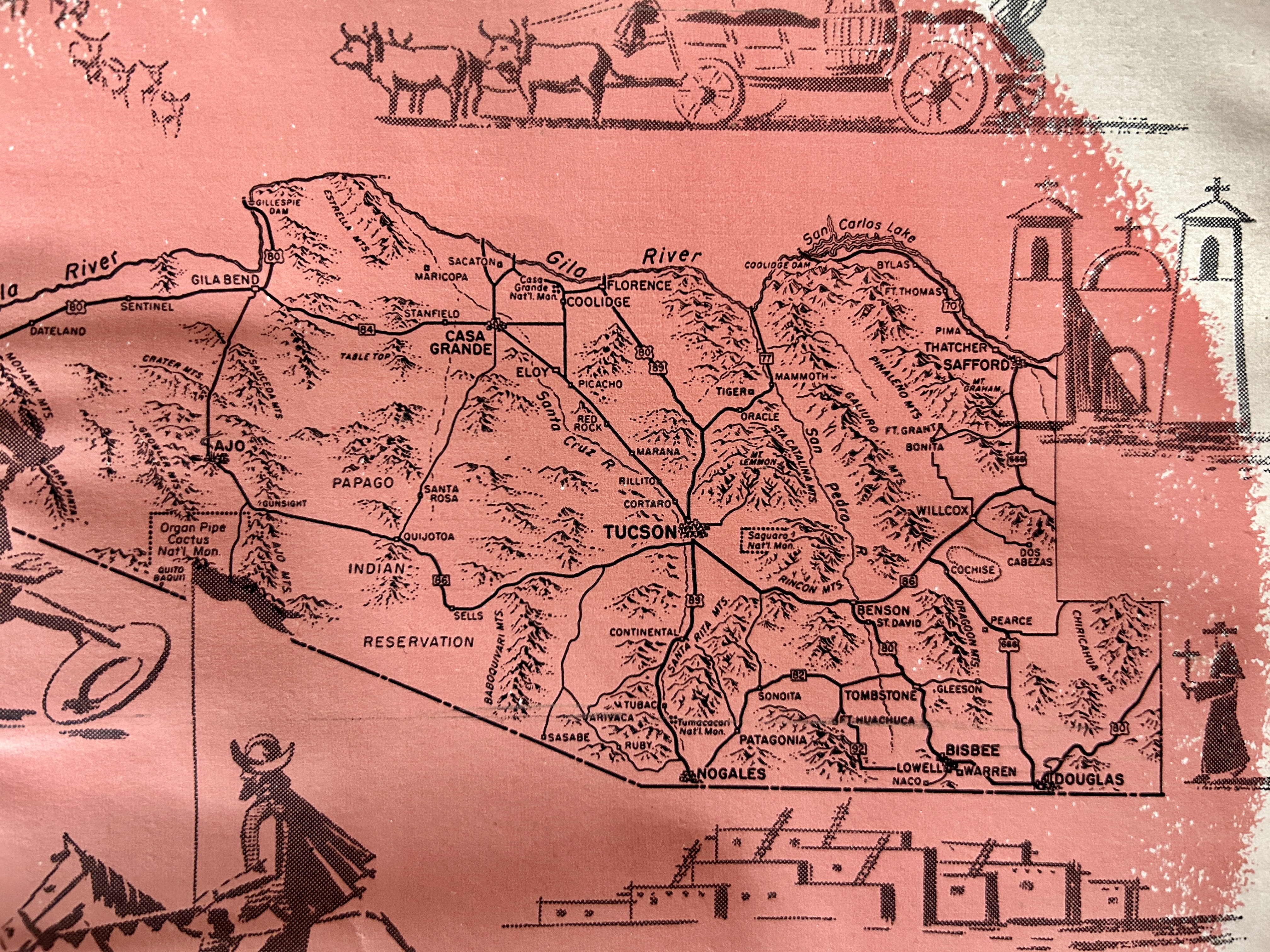
I take lots of breaks. In T or C I had a combo plate at El Faro. In Deming I visited the museum in the old armory building and their beautiful Mimbres pots. In Benson an attentive docent showed off old medical ephemera, rolltop desks, and a collection of railroad and mining stuff. I continued west in a history quest and was richly rewarded in Dragoon Arizona at the Amerind Museum, Art Gallery and Research Center.
The old ranch established by William Shirley and Rose Hayden Fulton in 1930 was named FF Ranch. William had a passion for Native American artifacts and culture and she had a passion for Quarter Horses. But the horse business part of Amerind stopped when the horsewoman Rose died in 1968.
William Shirley Fulton was a Yale graduate who ran a foundry in Waterbury Connecticut for 25 years before retiring and devoting himself full time to his passion for archaeology. His first explorations of Arizona and New Mexico probably started after his marriage as his father-in-law owned interest in a copper mine in Jerome, Arizona.
The Fultons established the Amerind Foundation in 1937 and opened the extensive collection of artifacts to the public. Permanent collections include a century’s worth of Zuni and Navajo jewelry, and a well curated trove of items from Paquime. There are items with carefully curated text about language and cultural groups from all over the Americas.
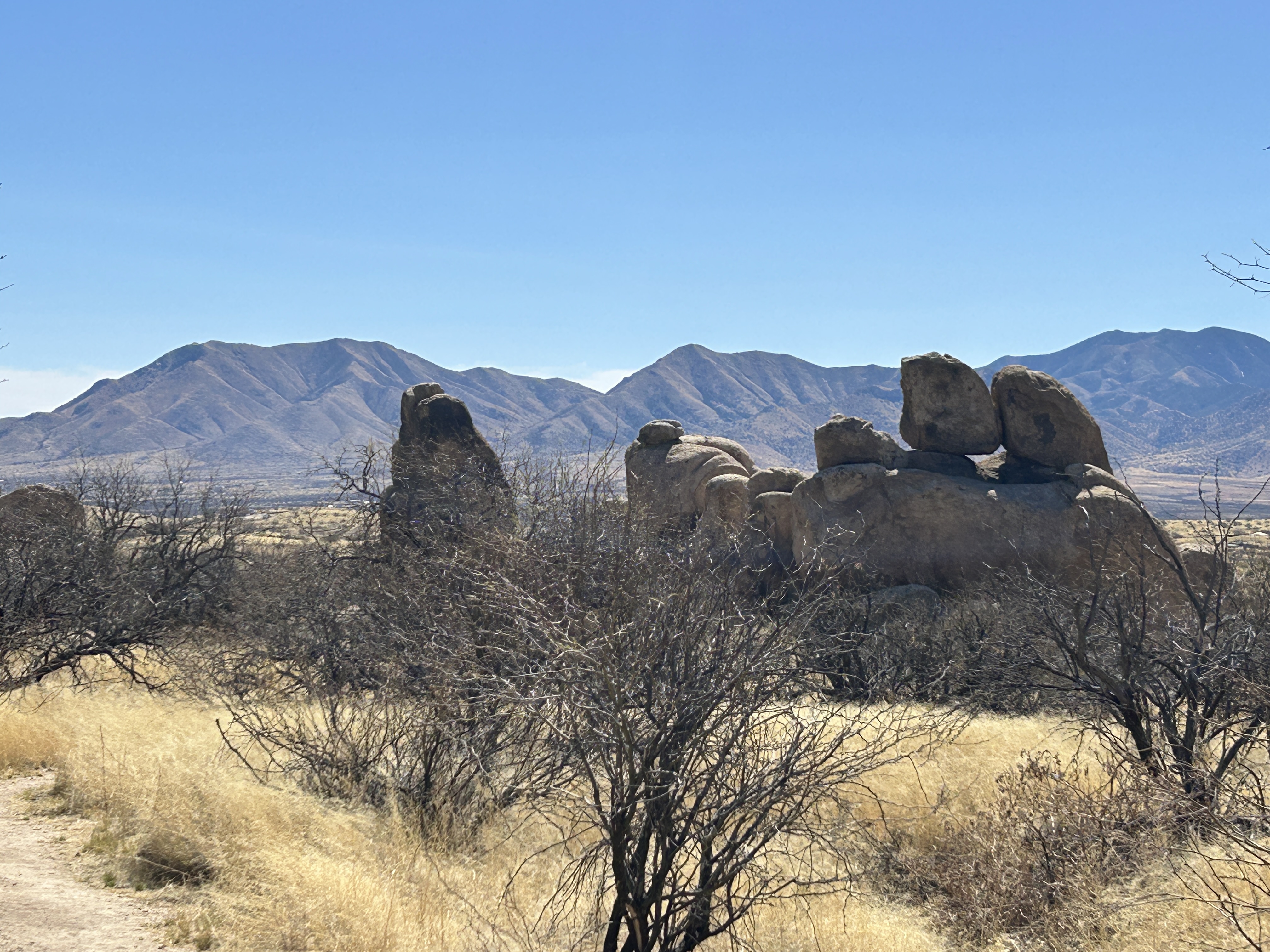
The multilevel building of rose stucco and arches hosts special events. There is a large research library that includes Fulton’s rare book collection. There are also six miles of well maintained scenic trails. I walked through and around the huge boulders before the wind came up. I would have to visit again.
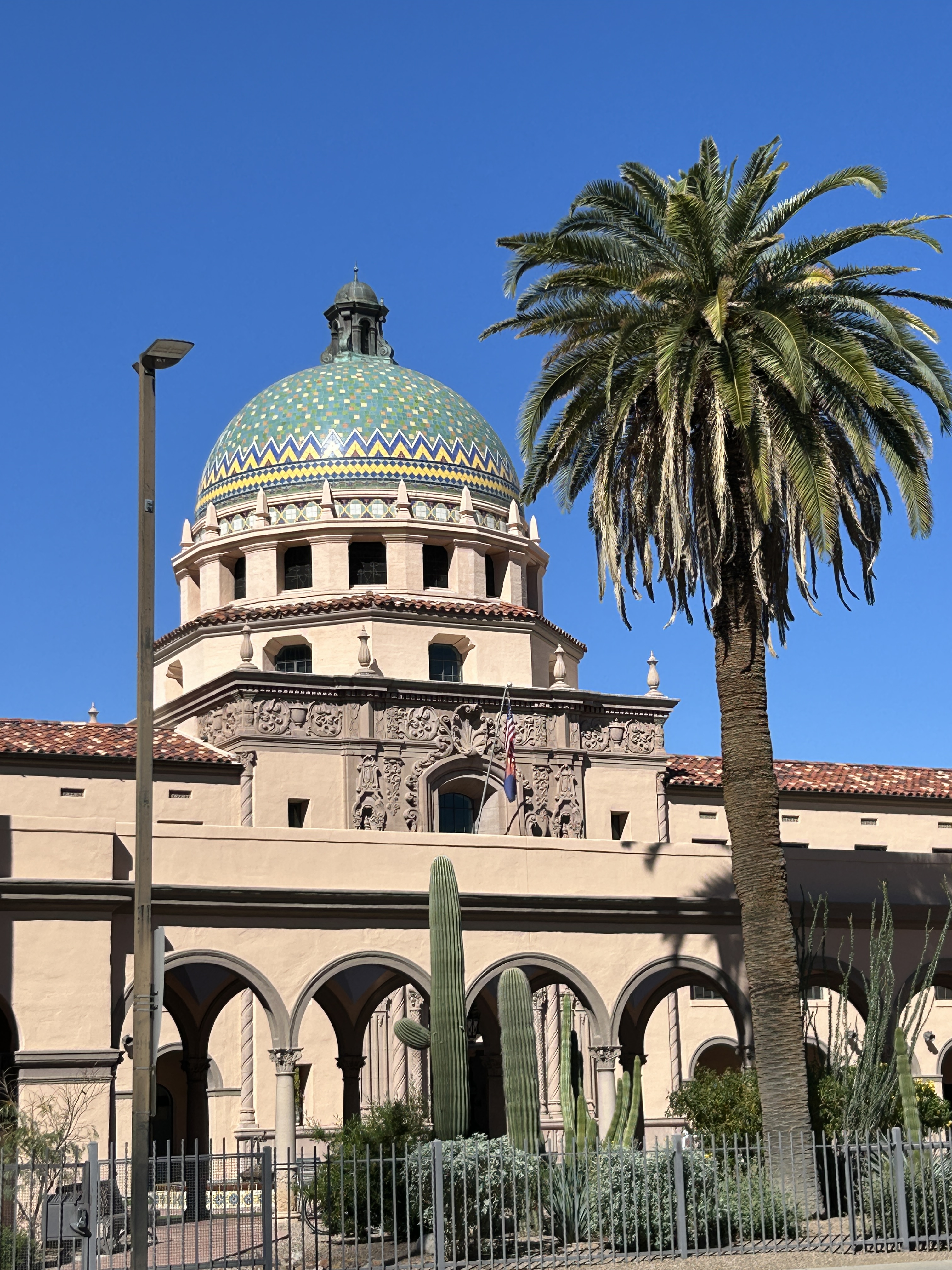
The wind was roaring when I reached Tucson and checked into my beautiful room at the Arizona Inn. It was designed by the same architect the Fultons hired to build Amerind, Merritt Starkweather. He favored the Mission style and dusty rose stucco.
Is this thing on?
The 2025 Tucson Book Festival at the University of Arizona went fast. It was well-organized and full of great speakers. The technical problems that seem to plague most live productions were virtually absent or invisible. It was fabulous, free, and packed. (I am never alone.) I listened to seven sessions in the two days, mostly about politics, and came away informed and inspired, if not uplifted. I also purchased books. Note for next year: budget for the books.
Session titles like The Dangerous Manipulators, Freedom Under Fire, Searching for the Truth, and Reconciling in Trump’s World capture the drift of the presentations I saw. Random notes and ideas I gleaned: You must stand up and out of the box. Just voting isn’t enough. There hasn’t been a President Turley has liked since Madison. The Federalist Society is now the GOP’s “one stop shop” for judges. Free speech laws silence the wrong people. Speech conduct and content are different and should be. Fifty years of not weaponizing the Justice Department has vanished. Just the facts won’t work to convince the right. There are no good billionaires who’ll save us.
There is hope in the local.
I needed to explore the desert to recover.
I toured the Los Morteros Conservation Area in Marana and the Picture Rocks site on Spring Equinox with a guide from the Old Pueblo Archaeology Center. Los Morteros is a Hohokam site featuring mortars in natural rock outcrops used to grind mesquite pods into flour. While we were walking I ordered mesquite flour that I’ve since used to make cookies and pancakes. It’s orangish in color and has a nutty flavor.
The Picture rocks site features a sun spiral with a shaft of light or dagger that points to its center at midday on the Spring equinox. We careened to the site in a caravan of cars and arrived at the Catholic retreat to watch as it happened. Tour attendees were respectful and quiet but for the memorable and not insignificant sound of feet crunching through gravel.
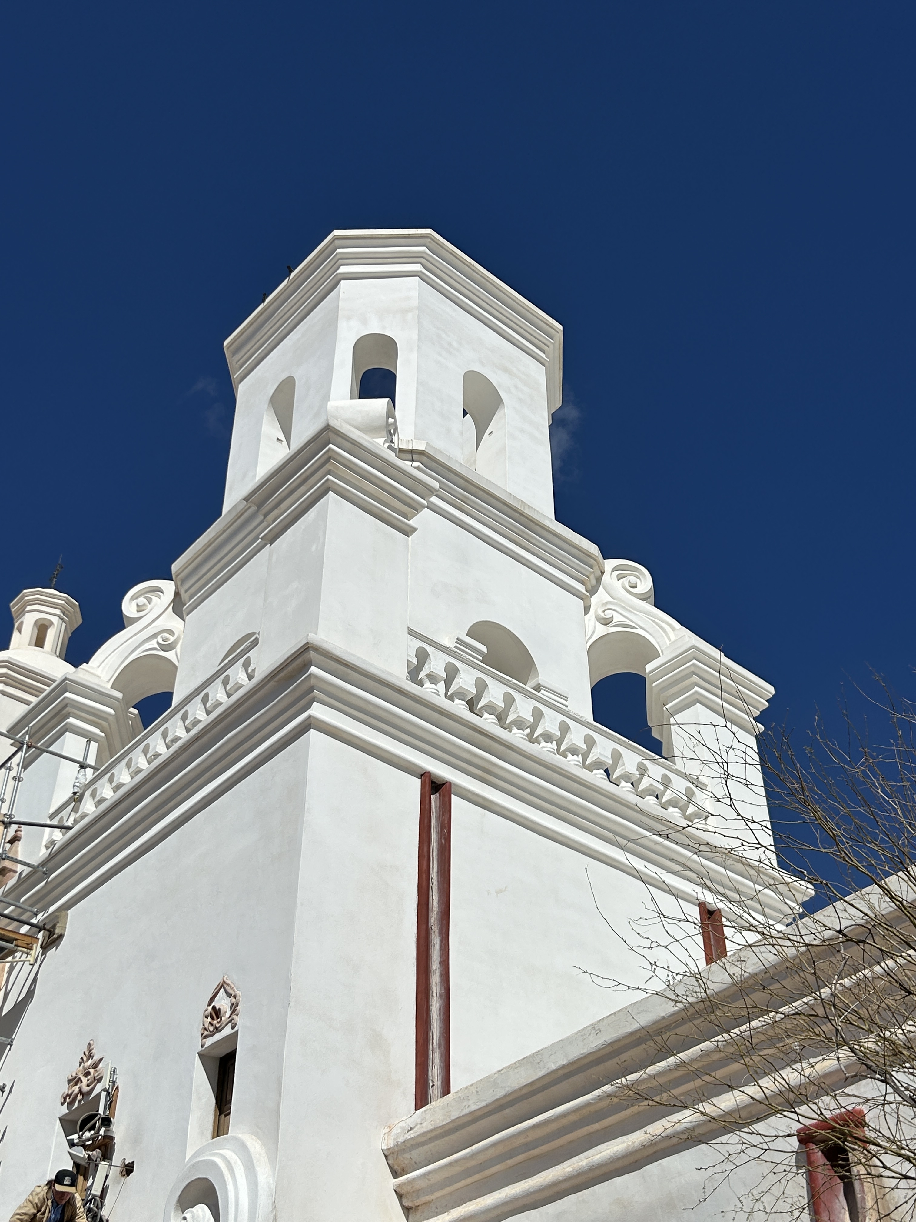
On another tour of the San Xavier del Bac Mission I learned about Father Kino who established it and many others. I found out that it was once a part of the Santa Fe diocese. The Spanish Gothic architecture is unique and unrivaled, even by the California missions. We were told it was once abandoned completely and that people took shelter within its walls, making fires that blackened the wall paintings that took decades to clean and restore.
The Mission Gardens are located at the site of a village and another mission once located at the foot of Sentinel Peak. The site is Tucson’s birthplace and origin of its name, “Cuk Son” meaning something like “Black Base.” Over 4000 years of cultivation has occurred at this location in the Santa Cruz River floodplain. The plots each demonstrate a different era in Tucson’s agricultural heritage, from Native American to Statehood. Heritage chickens roosting in an ancient coop. Quail running around the agave, huge roasting pit like the Hohokam used to process agave. Millstone and threshing ground. Dozens of citrus trees in full fruit. Quince and orange jam grown and jarred there for sale with other things.
At the 49 acre Tohono Chul gardens I watched an outdoor performance of Mozart’s opera, The Secret Gardener, by Arizona Opera. At Centennial Hall on the UA campus I saw the Martha Graham Dance Company perform. I visited the Tucson Botanical Gardens, Tucson Museum of Art and the Fourth Avenue Street Fair. Both days. I took tours of Barrio Viejo and Fort Lowell.
My immersion into Tucson came to a noisy climax downtown in my final nights at the Hotel Congress.The place is full of vintage elements, like old tile and plumbing. It’s bars and stages host renowned performers. I enjoyed jazz and flamenco shows.
Guests are warned it is a loud hotel. You’re asked to sign something acknowledging this when you check in. Somehow I thought it was about the music. At 10:53PM, after the kitchen fell silent, yelling began. I pulled off my headphones. He didn’t seem drunk. He wasn’t slurring his curses at all. The hotel heaved a collective sigh – what an asshole everyone grumbled at once. His shouting continued, reverberating down the halls with perfect clarity. A woman pleaded with him and a little dog barked. At one point someone asked him politely. Dude, we’ve got kids. We’re trying to sleep. He was sneering and mocking the guy. It got quiet soon after that. In the morning someone at the reception desk apologized and said the police took him away. Subsequent nights were much quieter.
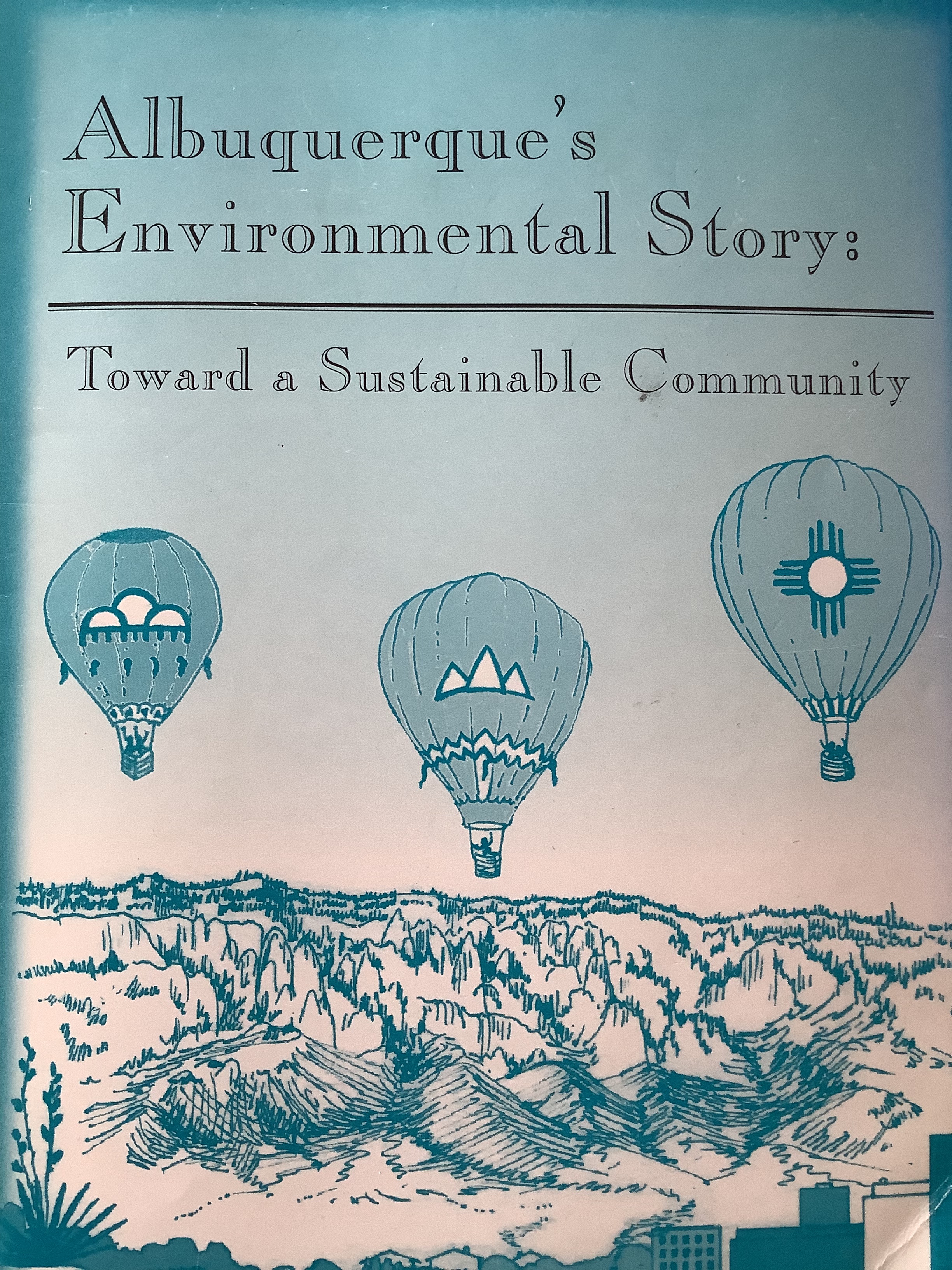
Albuquerque’s Environmental Story: Toward a Sustainable Community is a 462 page teaching resource for students and adults.
“(A) holistic overview of the Albuquerque area’s human, built, cultural., and natural environments… designed to inculcate a sense of community among the young and to achieve attitudinal change among adults…to raise consciousness through appreciation as well as interrelated , interdependent sharing of this ecosystem to achieve knowledgeable , responsibly involved citizenry.” Hy and Joan Rosner
Joan and Hy Rosner undertook the long running effort to fund, organize, promote and write three editions and an online version of the document that is still available on the Albuquerque Historical Society website.
The Albuquerque Conservation Association was honored to have participated as the non-profit sponsor of the effort prior to establishment of Friends Of Albuquerque’s Environmental Story in 1999.
The encyclopedic reference book documents every aspect of the community, including topics of geology, air and water quality, solid and hazardous waste, energy, historic preservation and the built environment, including descriptions of 11 neighborhoods, the East Mountains and Rio Rancho.
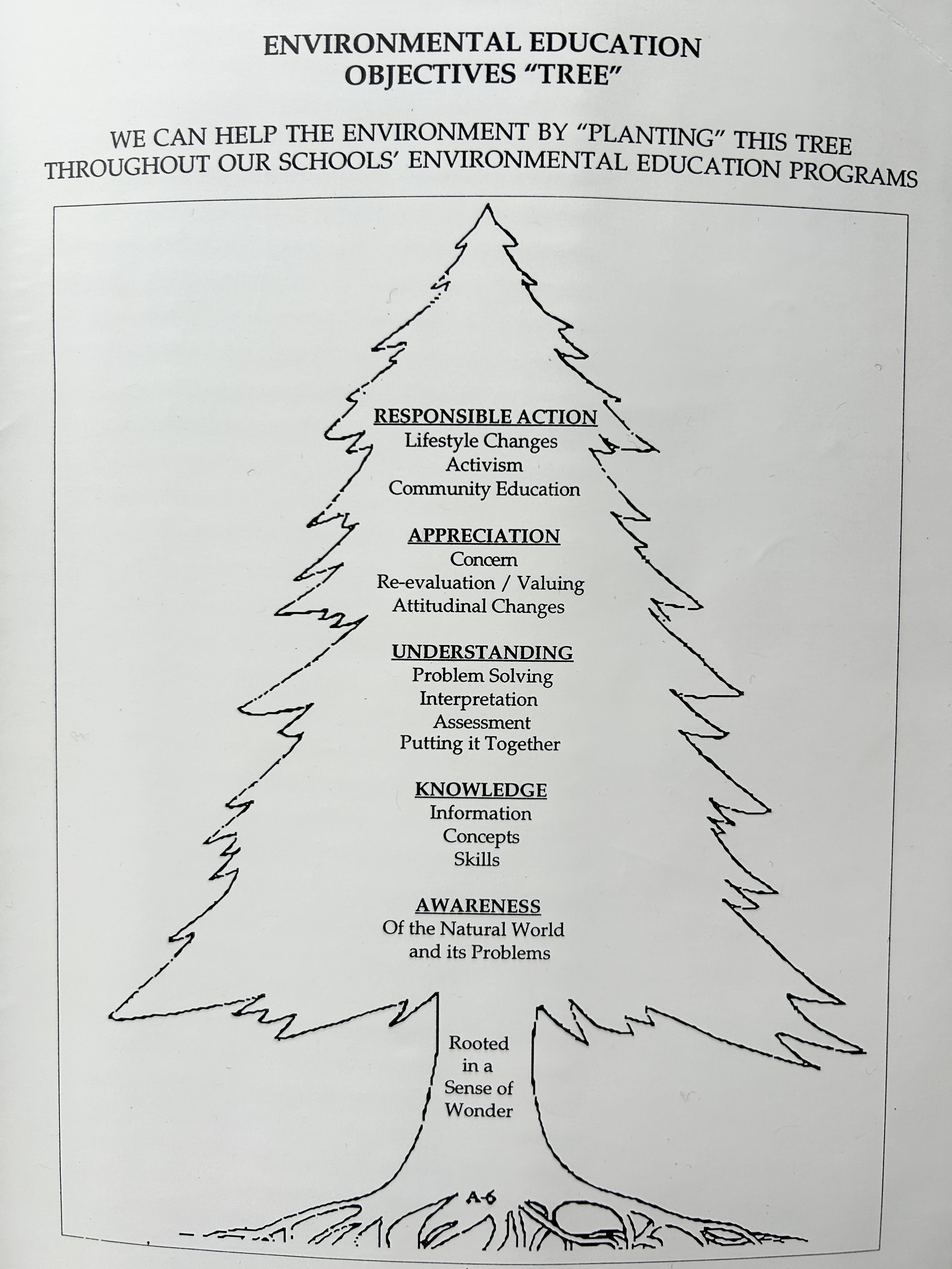
The book includes teaching tools called “Eye Opener Worksheets” that outline activities and ask questions to spur thoughts and discussions for the classroom. It also contains multiple extensive bibliographies and appendices.
The first version was published in 1978 . It was revised twice and in 1988 the Rosners also oversaw production of a slim condensed version called, “Albuquerque: City of Contrasts.”
I visited the Rosners’ home on Sunningdale in the late 80’s. Their large dining room table was covered with orderly piles of paperwork related to the document. That table was symbolic of the effort to which they devoted their lives and personal space to the work. Their enthusiasm was contagious.
Financial support from businesses, including AT&T, Intel, and PNM made the work possible and volunteers from the City, County, Albuquerque Public Schools, and groups such as 1000 Friends of New Mexico, Central New Mexico REBUILD AMERICA, AIA Albuquerque, Cottonwood Printing, Shared Vision, and the American Architectural Foundation were involved. Mayor Martin Chavez provided the forward to the 1996 edition. Over thirty individuals were involved. The result was a thorough and balanced treatment of all aspects of Albuquerque and the region.
A city beautiful, a balanced city that works for all of us, must have the informed participatory backing of an enlightened citizenry, a recognition that the environment is all embracing, that it touched all our lives.” Hy and Joan Rosner 1987.
The growth of Albuquerque has not eclipsed the Rosner’s work. AES is a lasting legacy of the Rosners and to the spirit of Albuquerque’s places and citizens.
I announced this on my return to the upper parking area. The very talkative volunteer turned silent and everyone in the assembled tour group turned to stare. It was a chilly vibe. Reading the informational material afterwards I saw it: No food or picnics. The reasoning hinted at aggressive wildlife. It’s not like I took a cooler but it was awkward.
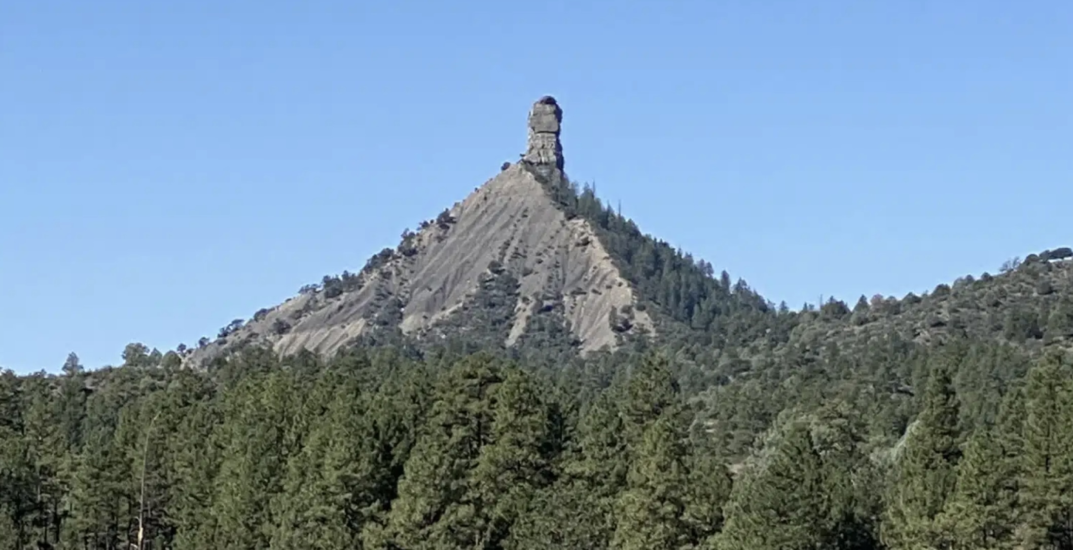
At the base of the chimney and companion – site of fire lookout, signal fires
Anyway, the small tahini and honey sandwich crammed in one pocket and the larger water bottle sustained me on the short steep walk up the craggy ridge to the old fire lookout site. So did the hiking shoes and walking stick.
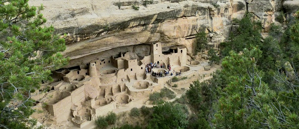
I was the first visitor up the mountain and up the trail. I got to the main entrance at 9:15. The contrast with Mesa Verde is profound. I was alone except for a few staff and volunteers. It was the end of the season so you could drive yourself up instead of going in vans.
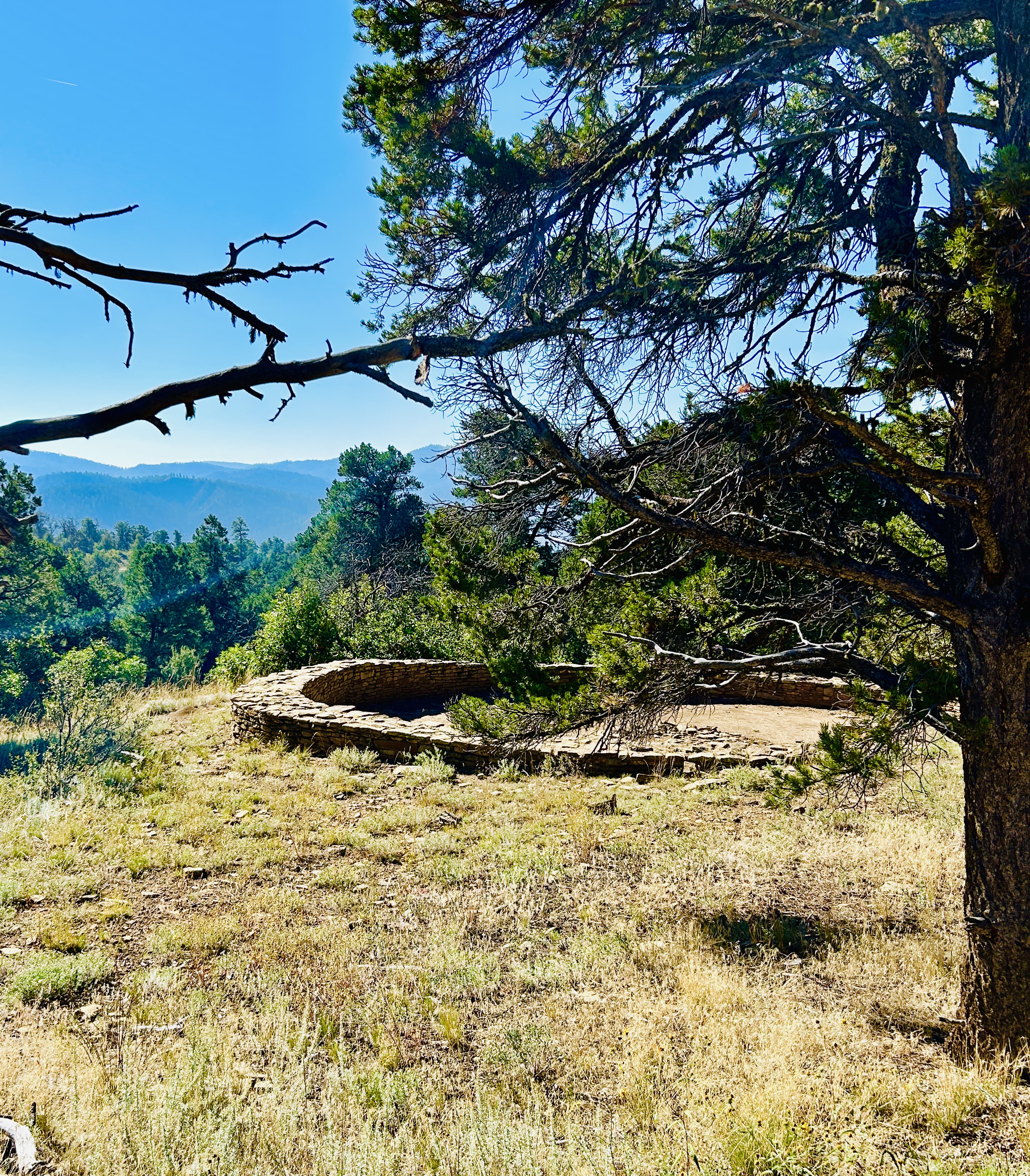
It’s a stunning landform even without knowing its significance to ancient people. They must have felt a similar sense awe. Racing along US 160 West of Pagosa Springs today we come upon it fast and dramatically. The Chimney and Companion rocks poke up from the top of a mountain that towers over the Piedra River between two other river valleys.
From Visit Four Corners
At the height of occupation the ancient pueblo people grew corn, beans and squash in the valleys. They lived in smaller scattered farming villages, most within a mile of the upper pueblo where a 44’ great kiva is located. This is 90 miles from Chaco Canyon and considered the Northeastern most Chaco outlier. Signal fires were used and I expect there was a code language. There is a lumber camp theory that trees were harvested from here for construction elsewhere. Like other Chaco pueblos, it was abandoned after 1135.
There’s another big kiva surrounded by rooms at the very base of the big rocks. I walked up the steep narrow “causeway” to the old fire tower location. The tower was removed in 2010 and beneath it archaeologists found the 1000 year old signal fire pit. Interestedly, the signal fire communication potential wasn’t proven until a Farmington high school student, Kathy Freeman, used mirrors to relay light from here in 1990.
Chimney Rock National Monument, unlike Mesa Verde, is closed in the winter months. So plan accordingly. It’s not too far west of Pagosa Springs and its famous hot springs. Further west is Durango. Visit Four Corners has a good page about all of it and more.
I sat on the edge of the lookout foundation and ate my little sandwich. A huge raven circled overhead several times, eyeing me. He knew the rules.
Today’s experience visiting Mesa Verde couldn’t be more different from 1000 years ago if we were dropped down from space. We move on asphalt networks in metal capsules of varying sizes, hopping in and out of them (over twelve times by my count) at carefully positioned locations to view ruins covered by monstrously unattractive metal buildings. Funny thing is, I don’t mind. It is a very special place in spite of this strange and temporary connection.
The mesa changes from verde to oro this time of year as oaks and serviceberry turn. I imagined thinner crowds and cooler weather but the parking lot at the big Visitor and Research Center was already busy at 9:45AM and it was warm on the mesa by noon.
TACA Board Member Jerry Widdison remembers visiting the park with his family after the war. They stayed at the Aneth Motel in Cortez. It’s still there. Aneth is a word in many languages but Jerry said it’s Navajo and also a Utah place name. The origin may be a nickname given to a greedy Anglo trader meaning just like a devil. The term was used more widely about unsavory business practices at trading posts.
The Drive
At the entrance kiosk up the road I bought an Annual Senior Pass which is a very good deal. The man staffing the kiosk was a quintessential park ranger in full uniform, full beard, dark sunglasses and Smokey Bear hat. I resisted asking, “All set for Halloween, are ya?”
It is a great road up and across the big mesa and its smaller mesas, that reach like fingers between multiple canyons. There are stunning views from several overlooks. Jerry recalled the hair raising part of the route called “The Knife Edge” that’s now a trail. A tunnel replaced this section of the road.
Far View Ruins site was my first intended stop but, like all of Wetherill Mesa, it was closed. With no choice, like everyone else that day, I went on southward on Chapin Mesa to the museum and two loop roads.
It’s clear from old maps and aerial photos that ruins are all over Chapin Mesa but you can’t see the archaeology from the roads and you’re not allowed off them. This is by design. It protects the sites and landscape from being over-run by humans, no doubt. It also means you can be well over two hours into the park before ever seeing a ruin.
Jerry also recalled that the tours of the famous cliff dwellings were first-come-first-served and that you could walk into many of them unaccompanied by a guide. Those days are gone.
Park History
The people behind designation of Mesa Verde as a National Park in 1906 included women. Virginia McClurg (1857-1931) started a movement to preserve the cultural treasures of the mesa. Lucy Peabody, (1863-1934) the “Mother of Mesa Verde” worked nine years to gain national support for park creation, including negotiation with the Weminuche Utes.
Wetherill and Chapin Mesas are named after Richard Wetherill and Frederick H. Chapin. Along with Wetherill’s family, including Marietta Palmer Wetherill, they explored the ruins during the summers of 1889 and 1890. Chapin wrote the first book about the place in 1892, “The Land of the Cliff Dwellers.”
Wetherill was from a Quaker ranching family that settled in the Mancos River valley in 1880. He ran trading posts, including one in Chaco Canyon where he was murdered in 1910. Artifacts he and his family collected were subsequently donated by Marietta Wetherill to the University of New Mexico.
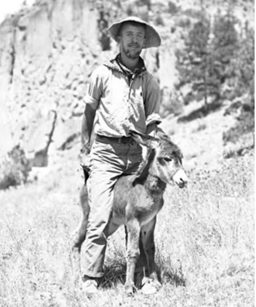
Jesse Nusbaum NPA photo
Perhaps the people with the mostly visible modern impact on the park were Jesse Nusbaum and his wife Eileen. Jesse Nusbaum was selected as park superintendent in 1921 and began significant improvements in 1922.
Parkitecture
Before arriving at the museum I turned off on a whim to check out the picnic area. It was delightful. No other people were there. Old thick junipers shade the picnic tables. This was once the campground and the spaces and little roads are scaled for Model Ts. I found a choice spot in front of a serviceberry bush in full yellow fall color and saw a turkey, crows, and a hawk.
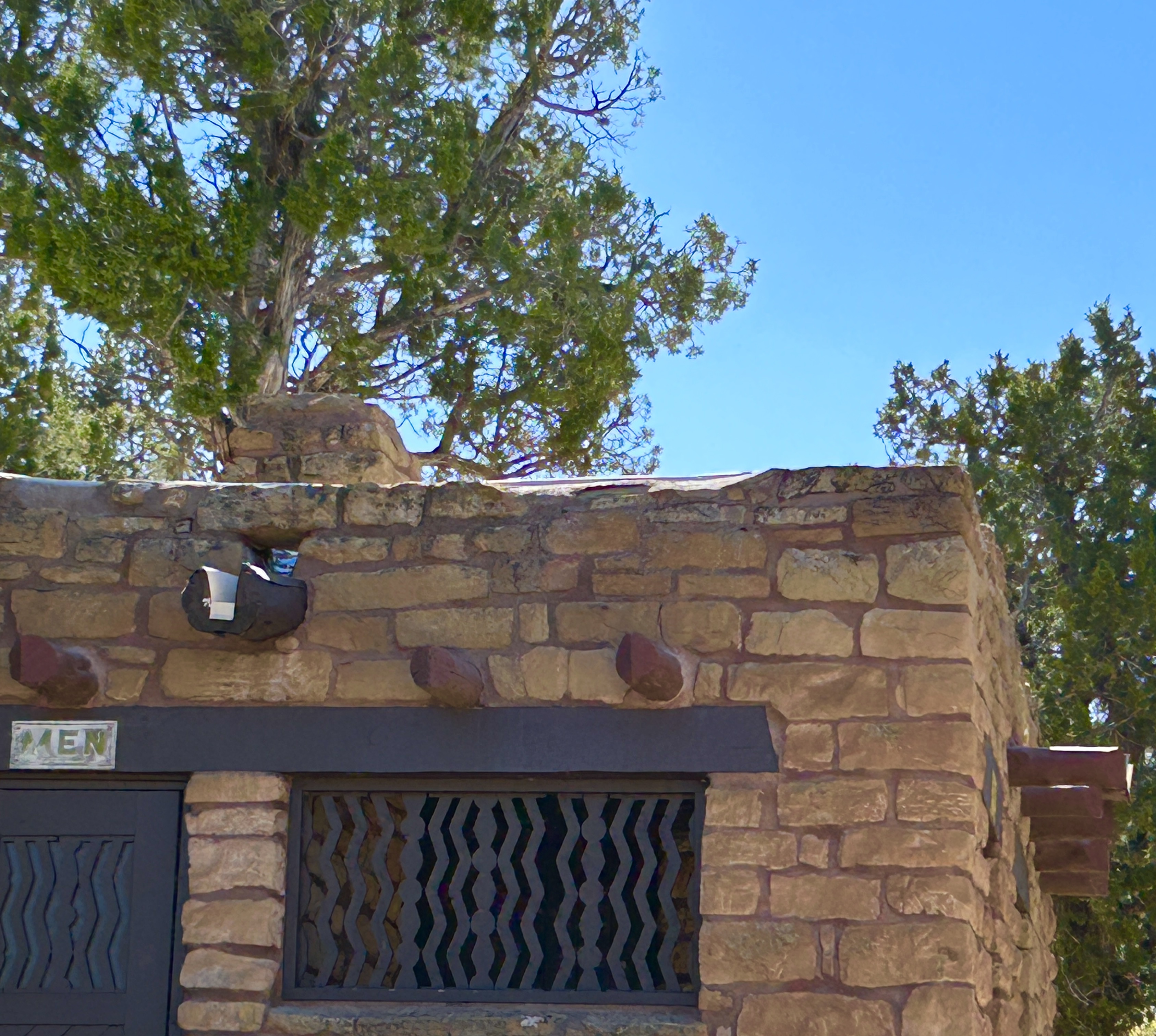
It was here in the old campground that first noticed a little sandstone brick building that looked a bit like an ancient pueblo structure. It was a restroom. The reinterpretation of ancient architecture for modern purposes at Mesa Verde in the early twenties created a cluster of unique historic buildings on Chapin Mesa – a layer of history upon prehistory.
Jesse Nusbaum (1887-1975) was born in Greeley, Colorado and became an archaeologist when the science was new. He studied teaching and then taught in Las Vegas, New Mexico before becoming an archaeologist and architect, undertaking work on new and ancient buildings, including the Palace of the Governors and the State Art Museum in Santa Fe.
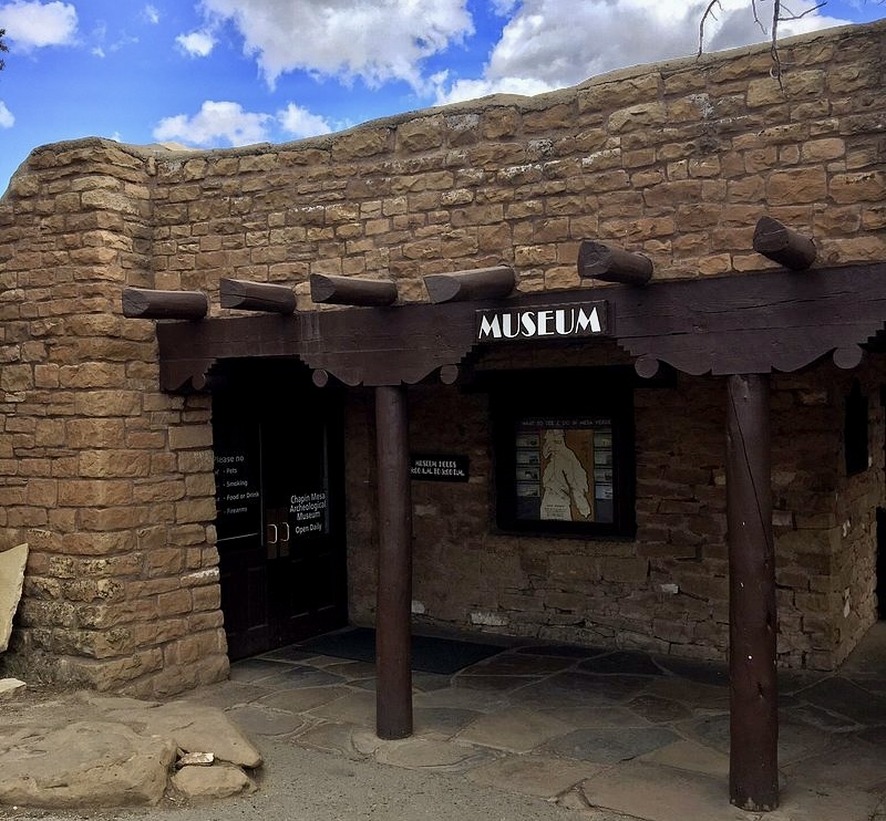
I left the picnic area and headed into that cluster of historic buildings – hidden in and among large junipers and punctuated by expanses of asphalt roads and parking. The museum was one of six buildings funded by JD Rockefeller Jr. and built by the newly appointed superintendent between 1922-1925, with an addition in 1939. It’s design subtly mimics a scaled down Spanish mission with a small interior courtyard (barely visible through the windows) and a “church” or auditorium where a film about the park was showing.
Ruins at Last
In spite of its position as the focal point atop the trail that descends into Spruce Canyon and Spruce Tree House – my first view of a ruin – the museum is underwhelming and crowded. The building was apparently tortured into ADA compliance and ramps consume entire rooms. It’s obvious a lot more money and effort have gone into displays at the visitor center at the entrance in recent years than at the old museum on Chapin Mesa.
There’ve been many fires but many beautiful trees remain. During the height of occupation in the thirteenth century, the plateau was largely deforested. According to dendrochronologists cited in the extensive wiki page about Mesa Verde, the last tree used in construction was cut in 1281. This marked the tail end of mesa occupation.
The loop roads have many overlooks from which to view canyon ruins. Jerry said he visited an overlook exactly 100 years after Wetherill rode a horse up to that same spot and saw Cliff Palace for the first time. It’s still awe inspiring.
I’m planning on visiting Mesa Verde again before my annual pass expires. I’ll never grow tired of trying to envision life on this mesa, even in the more recent past when visitors in early cars or wagons climbed the mesa over difficult roads to visit mysterious stone structures for the first time. Plenty of mysteries remain on Mesa Verde.
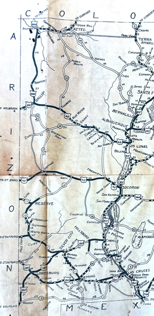
1927 NM highway map showing US 550 as 44 and the road west to Silver City, NM 152, as US 180
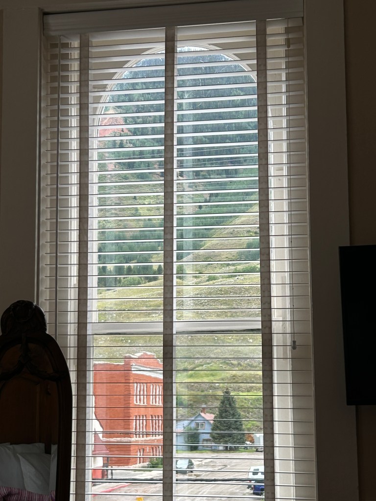
My first concern is no hot shower. The phone is charged, which is good because otherwise I would have missed the notice on my weather app about a “Regional Planned Emergency Power Outage.” That’s the wording. As a former city planner I’m especially amused by the oxymoronic term, ‘planned emergency.’ Apparently it provided “plausible deniability” for hotels that rented rooms in spite on knowing what was coming.
Up until then I liked my big bright corner room in the grand old hotel. The fire escape door at the end of the hall was tied open and there was a smell of room deodorant masking a sewer scent in the bathroom. But the mountain view – incomparable and stunning.
Red Mountain White Knuckles
The drive on US 550 between Durango and Ouray is intense. As kids we called the whole stretch the “Million Dollar Highway.” It probably costs at least that much every year just to maintain it. It is now apparently only called that between Silverton and Ouray. According to wiki, it’s the portion twelve miles south of Ouray – that last hair raising portion through Uncompagre Gorge, that gives the highway its name. Quick glances at faces in oncoming cars show passengers expressing worry or terror.
The highway is a staggering and impressive drive all the way from Albuquerque. It’s US 550 the entire way – Bernalillo on the Rio Grande Valley to Montrose on the Western Slope – through some of the most interesting geology in the west. Portions follow routes used in prehistory and the Old Spanish Trail. In the San Juans a man named Otto Mears built the first tollroads on parts of what became 550. Then he built the first railroad to Silverton. Collectors of railroad memorabilia love his Silverton Railroad passes, printed on buckskin and adorned with silver filigree.
It’s nice to divide the drive into two parts with a stop in Silverton for relief from the cliff-clinging road. A free Shakespeare production of As You Like It in intimate little Anesi Park that night was delightful. Multiple sponsors included UpstART Theater That Moves. The play was also preformed in Ouray.
The Silverton history museum has expanded from the old jail to a mining boarding house donated to the San Juan Historical Society and moved to town. In and under those buildings is everything related to mining but a live burro. A mineral exhibit has me transfixed and I stare at innocent looking yellow uranium powder for probably too long wondering if it’s safe.
My second concern on the morning of no electricity, is no hot coffee. I thank my stars for the cold brew I bought yesterday in Durango and sit in my car taking big gulps while admiring the looming mountainsides. They’re illuminated like a stage backdrop by the rising sun. No stage production could match it. Somewhere someone is whistling.
The whole county seems to be lined up in the one coffee shop with a generator. There are delicious pastries. A hot cup takes over ten minutes. Everyone is listening to city workers – big guys in work clothes talking loud and greeting each other as they file in between the tourists. One guy says marijuana is a gateway drug and another says it sure was for him. The whole place erupts in laughter.
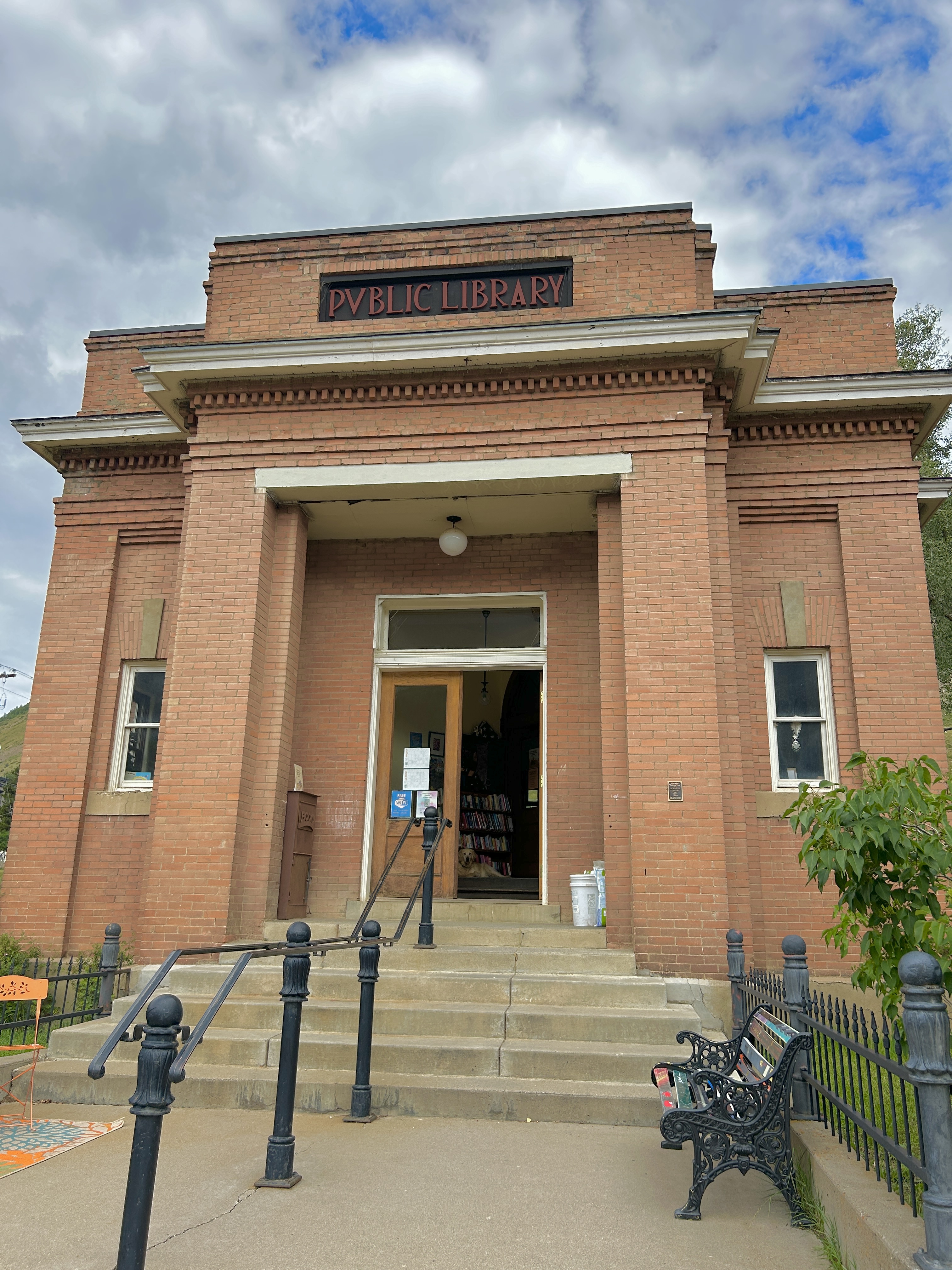
Carnegie Library, Silverton CO
I love old places, including big richly storied western hotels. I worked at an old resort near Denver for a summer in college. It was memorable. I can smell it now – old wood and dust. The work was grueling – dragging an old vacuum cleaner to hillside cabins, cleaning all day after serving breakfast then cleaning up to serve dinner. The six of us lived in a bunk room under the porch with no insulation and touchy wiring. No one could use a blowdryer without blowing a fuse and this was the late seventies so that was a problem. We got one day off a week, separately. I would drive to Denver in a borrowed VW beetle alone to watch The Rocky Horror Picture Show.
It was pretty – that canyon and the trees and the grand old three-story tower. We rattled the bones of that building at square dances in the lobby, attendance at which was mandatory. Sometimes people played the piano. The whole place seemed alive.
Give me an old hotel over a new dull and anonymous one any day. But some people think that’s what a hotel should be. They don’t want character, just sleep. Preferably with electricity.
Silver City
A few weeks later I drove west to Silver City from I-25 through the Black Range. It is a magical and less scary for the height conscious passengers. I remember boys at NMSU hauling bicycles up and riding them down the curvy steep bits above Kingston. I drove the pickup. No one was hurt, remarkably. Tiny grey deer under ponderosa watch the occasional traffic. I try and take photos but end up attempting watercolors later for the first time in years – simply inspired.
Silver City is a good and interesting. It’s one of those places where the rolling Wheel of Fortune has been very visible and left an indelible track. Artists and seekers sometimes come to places like this. Sometimes money or popularity “ruin it” and we’ll talk about how Vail or Durango or Santa Fe used to be. Silver is like that now. I’m sure it’ll change again. Cultures have been displacing, absorbing, undermining each other from prehistory. Land and landscapes used and abused. Mountains turned upside down for copper. Rebellion over cows to controversial feral cow elimination.
It’s always the end of an era. Sometimes things get better. Sometimes (usually) long after “we” are gone. Like how a flood in 1895 washed out Silver City’s Main Street leaving a 55 foot deep trench. Main street became the next street over. Now the trench is a pretty linear park.
The copper mines could be a set piece for the recent Netflix series “KAOS” with Jeff Goldblum as Zeus sitting in a giant excavator observing the miles-wide pockmarks, seeping festules, funny-colored fake mountains. A friendly cowboy in the brew pub said when dust from blasting settles on cars it eats away the paint, “and that can’t be good.” He knows dust, being from where dust storms frequently close I-10. I asked if the mines employed many people. He said he didn’t really know but that they’ll never close them. They’ll always keep “a skeleton crew” to avoid the costs of reclamation work required when they close.
I stayed at the Murphy Hotel, a downtown classic. It is solid, simple, nice. I like to pretend I’m the Hotel Inspector. That reality show follows famed hotelier, Alex Polizzi, around Britain as she visits and critiques hotels and B and Bs. I don’t have her background, experience, heritage or chops, but I know good vibes and clean sheets when I feel and see them. I also see that cool Mondrian inspired mural on the back wall across from restored old brick buildings. I can smell the sweet little bakery downstairs around the corner.
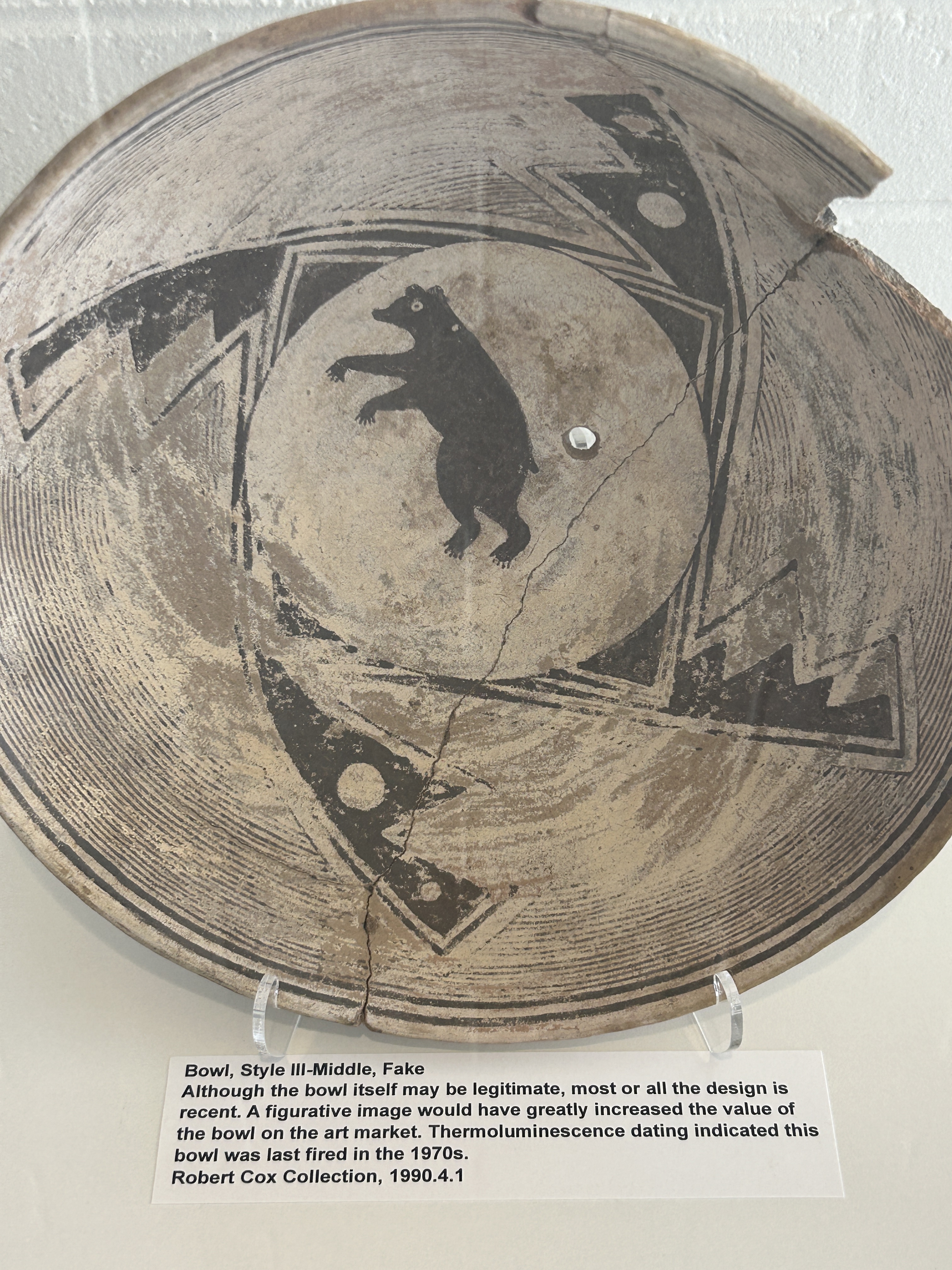
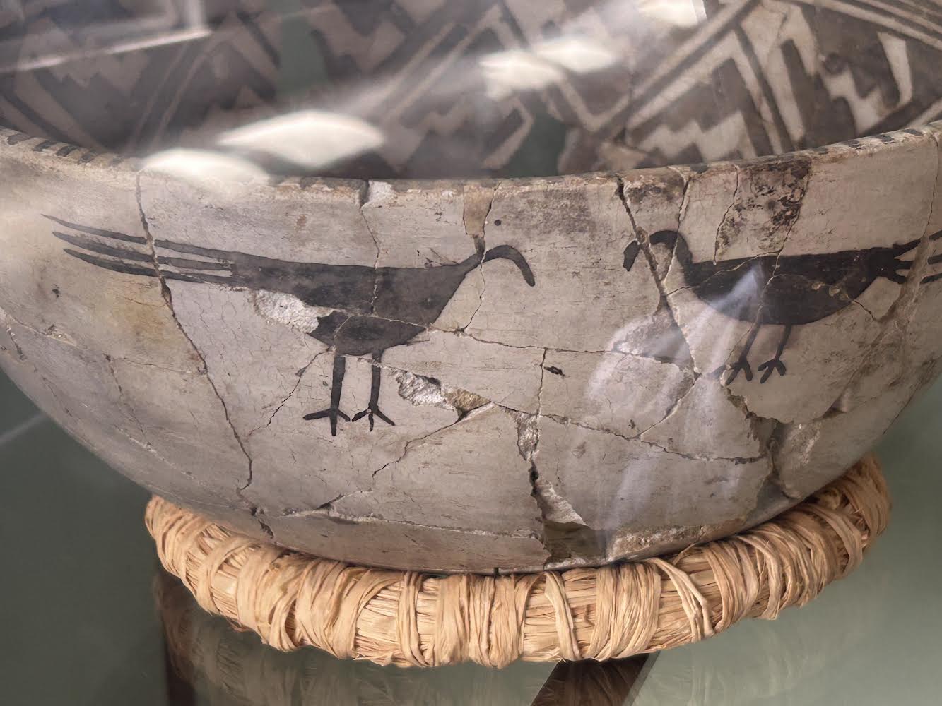
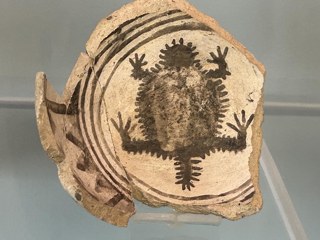
Mimbres pottery is a reminder of prehistory and that spinning wheel of time. Western New Mexico University has a huge collection housed in a beautiful 1917 Arts and Crafts building. The distinctive black on white Mimbres pots with animal images became so popular with collectors that ancient sites where the pottery originated have been routinely destroyed. A century of looting resulted in several large private collections that this museum has acquired for analysis and display.
Mimbres means little willow in Spanish. We don’t know what these people called themselves or the beautiful river valley where many villages were located. Similarly, the Mimbres are classified as part of the Mogollon culture, named after mountains that were named for a Governor of New Spain.
The Sonoran Desert
Interstate 10 is very bumpy and busy past the Arizona border. It’s best viewed as it stretches out in the distance on the descent from Silver City. Trainline-like lines of tractor trailers move back and forth. You barely see the cars, seemingly outnumbered by big trucks.
Arizona Highways November 1953 Commemorating “The First Hundred Years” of the Gadsden Purchase
This was part of the Gadsden Purchase – 45,000 square miles the US ripped-off from Mexico in 1854 for a transcontinental route and a railroad magnate’s aspirations. Mexico pretty much ripped it off from the Apaches who ripped it off from the Mogollon and Hohokam and Ancient Puebloans. All this within a millennium.
It never stops. Subdivisions punch holes in the delicate Sonoran desert. It is an honor and a tragedy to be this close. Like petting an endangered fish. I baby talk to javalina from a swimming pool and sketch quail from the bedroom window. The relentless wheel spins. What will be next, you can’t predict.
So breathe the delicate morning air. Enjoy the native desert. Come back when it’s cooler.
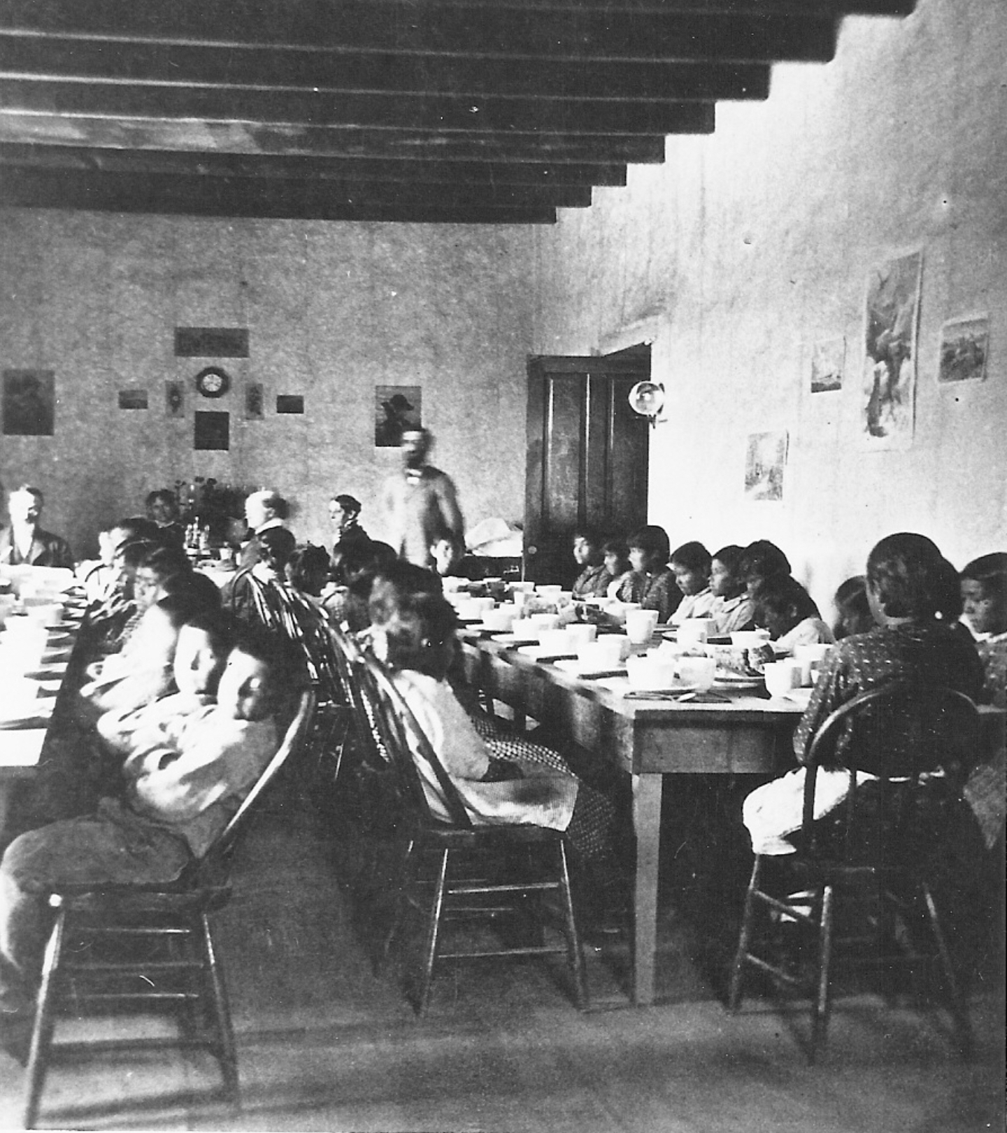
When the Albuquerque Indian School (AIS) was established in 1881, it brought together students mostly from the Pueblos and other Southwestern tribes. Bringing children of different ages and tribes together in a concentrated and regimented way had an impact on the health of the school community. Contagious infectious diseases such as influenza, scarlet fever, measles and mumps could break out among students living in dormitories. Although the Indian Bureau provided medical care and vaccinations, these services were limited by low budgets.
Wittick, Ben, A visit to the Indian School Dining Room at Albuquerque, New Mexico, 1880-90? Courtesy of the Palace of the Governors Photo Archives (NMHM/DCA), Ben Wittick Collection, Negative No. 086868.
Even with the establishment of an Indian hospital on the AIS campus in 1890, there were students who died from epidemic disease outbreaks. In some situations, the remains of deceased students were not returned to their home communities. A cemetery was established on school property around 1885. The best information we have is that twenty five to thirty individuals were buried therebetween 1888 and 1932. There are indications that some of the individuals buried at this Cemetery were AIS staff members or Native people who died at the AIS Hospital. There are also recorded Native American burials in a dedicated area at Historic Fairview Cemetery, some of whom were AIS students.
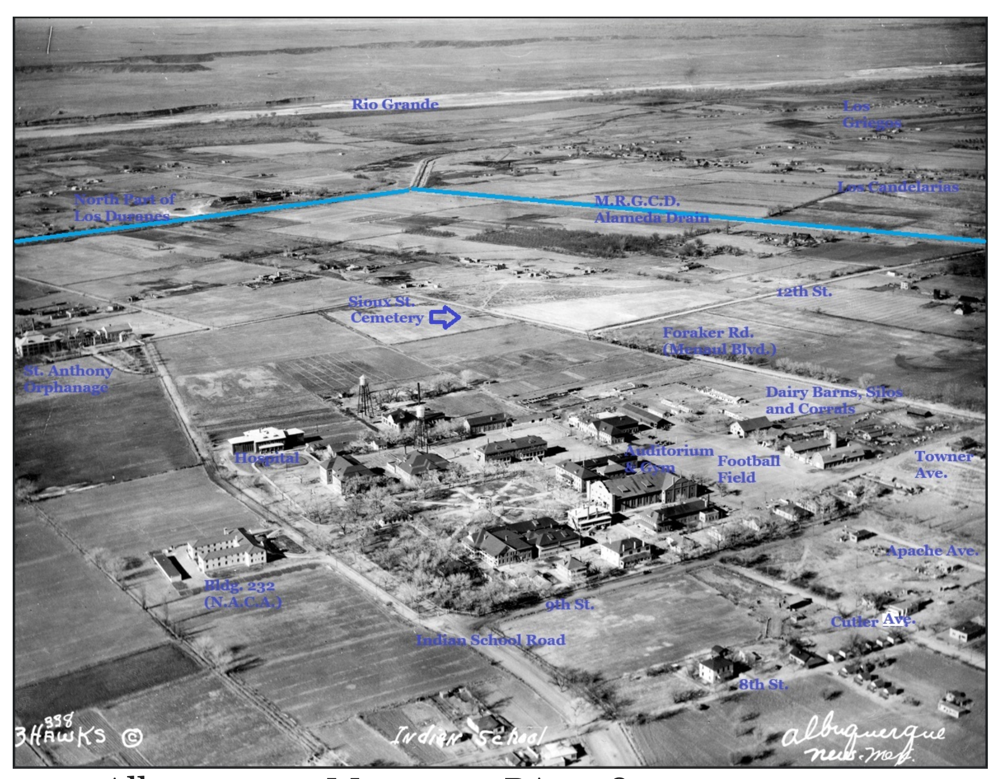
Albuquerque Museum – PA1978-141-20 ca. 1932
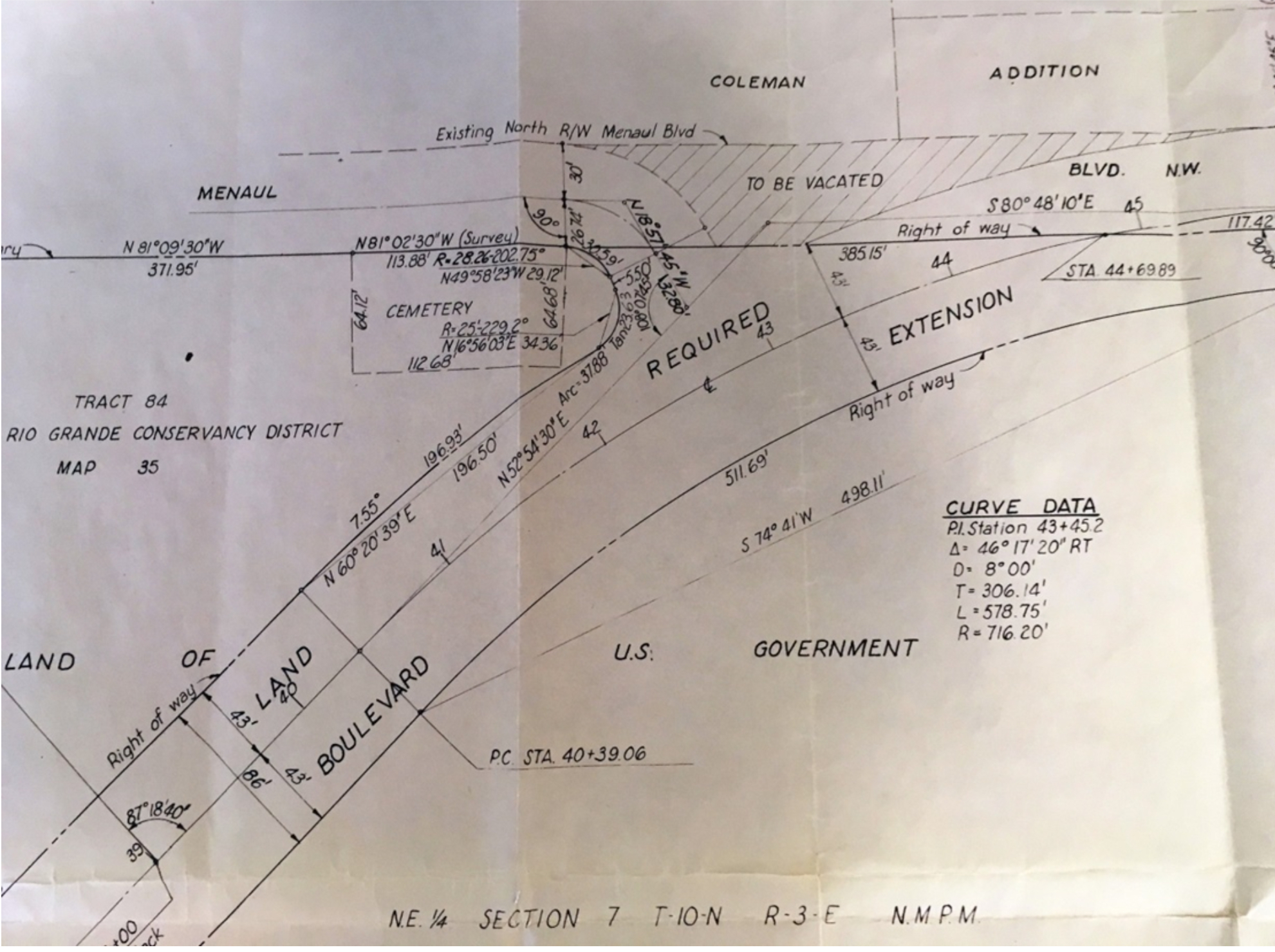
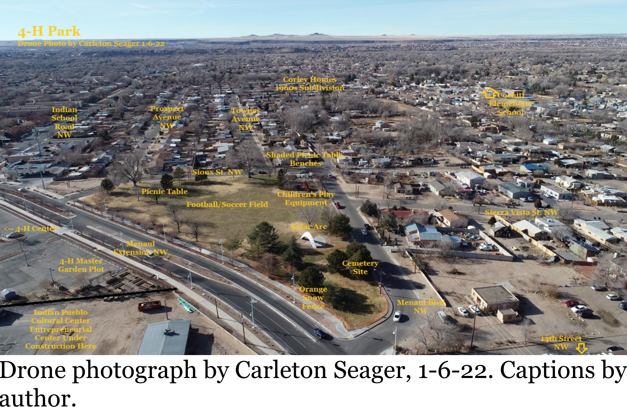
As AIS phased out its vocational agriculture programs in the late 1950s, the property west of 12th Street used for crops and grazing land was no longer needed. On April 25, 1960, the Bureau of Indian Affairs (B.I.A.) conveyed a 7-acre parcel of land to Bernalillo County, including the Cemetery grounds. The County leased part of the property to the 4-H Building Corporation, which established a 4-H Center and rodeo grounds. Other land transactions occurred in the next few years, resulting in the creation of a new diagonal street, Menaul Extension, connectingMenaul Blvd. with Indian School Road. The old route of Menaul Blvd west of 12th Street was adjusted to fork off of Menaul Extension next to the Cemetery. The City sub-leased the 2.95-acre triangular plot north of Menaul Extension from the 4-H Building Corporation on November 4, 1963, originally for a tree nursery, but ultimately for a public park they named 4-H Park.
City of Albuquerque Right of Way Survey, May, 1962. In Solar Arc project files of the Public Art Urban Enhancement Division.)
In 1992, the University of New Mexico asked the City to relocate the Solar Arc, a public art sculpture at Central and Girard NE. The local neighborhood association successfully requested that it be placed in 4-H Park.During the process of relocating the Solar Arc, City officials took the Cemetery’s location into account. At the dedication ceremony in 1995, Dr. Joe Sando spoke about the Cemetery on behalf of the Indian Pueblo Cultural Center. A quotation from his remarks was included on the plaque describing and explaining the Solar Arc. “In honor of former Albuquerque Indian School students interred in the burial ground nearby. ‘Few are recalled after going to rest as these resting here. Indeed, they are in peace.’ “
When AIS was closed in 1981, the students were transferred to the Santa Fe Indian School. AIS records were placed in a basement, and many of them were damaged in a flood. There may have been records in other files that remained on the remaining campus buildings. There were no resources to protect these buildings, and several were destroyed by vagrants starting fires to keep warm in winter. In 1992, the remaining campus buildings were razed. Most of the records from the school were lost during this period. It is likely that among the lost records was any registry of the names of the individuals buried in the Cemetery.
In 2019, neighbors discovered that the 1973 memorial plaque was missing. It seems highly likely that the bronze plaque was stolen for its value as scrap metal. During this period the theft of historical plaques in Albuquerque became a common occurrence.
When AIS was closed in 1981, the students were transferred to the Santa Fe Indian School. AIS records were placed in a basement, and many of them were damaged in a flood. There may have been records in other files that remained on the remaining campus buildings. There were no resources to protect these buildings, and several were destroyed by vagrants starting fires to keep warm in winter. In 1992, the remaining campus buildings were razed. Most of the records from the school were lost during this period. It is likely that among the lost records was any registry of the names of the individuals buried in the Cemetery.
Part 2.
Following revelations in June 2021 of unmarked gravesites at Indian Boarding Schools in Canada, protests and demonstrations occurred nationally about the condition of cemeteries at former Indian Boarding Schools. Native American demonstrators in Albuquerque noted that the missing plaque was typical of the dominant culture’s attempt to erase their heritage and culture. They placed ribbons, teddy bears and other children’s toys around a tree next to the missing memorial. Secretary of the Interior Deb Haaland announced a Federal Indian Boarding School Initiative, a comprehensive review of the troubled legacy of federal boarding school policies.
Photo by the author.
In response, the City of Albuquerque closed off the area around the Cemetery and initiated a public process with tribal involvement to acknowledge their responsibility for the site and to protect and commemorate the Cemetery. On September 25, 2021, Mayor Tim Keller held an AIS Cemetery Healing, Reflection and Memorial event at the Native American Community Academy, at which he apologized for the City’s treatment of the cemetery grounds. The City Council also passed a resolution of apology and commitment to do a proper memorial.
The City’s Office of Equity and Inclusion reached out to regional tribal governments seeking records about children who died while attending AIS. They sought input about the appropriate way to memorialize the cemetery. There were several public and online meetings seeking historical data and recommendations on securing and memorializing the Cemetery. The Parks and Recreation Department commissioned a survey of 4-H Park using ground penetrating radar.
The COVID-19 epidemic caused significant delays in the public process. In June, 2024 the Parks Department replaced the temporary mesh fencing enclosing the Cemetery grounds with a permanent tubular steel fence that matches the existing fencing along Menaul Extension. Community and tribal members will now have the opportunity to provide input on appropriately commemorating the century-long heritage of the Albuquerque Indian School and its Cemetery.
Additional information about the history of the Cemetery and the public memorialization process is available on the City of Albuquerque website.
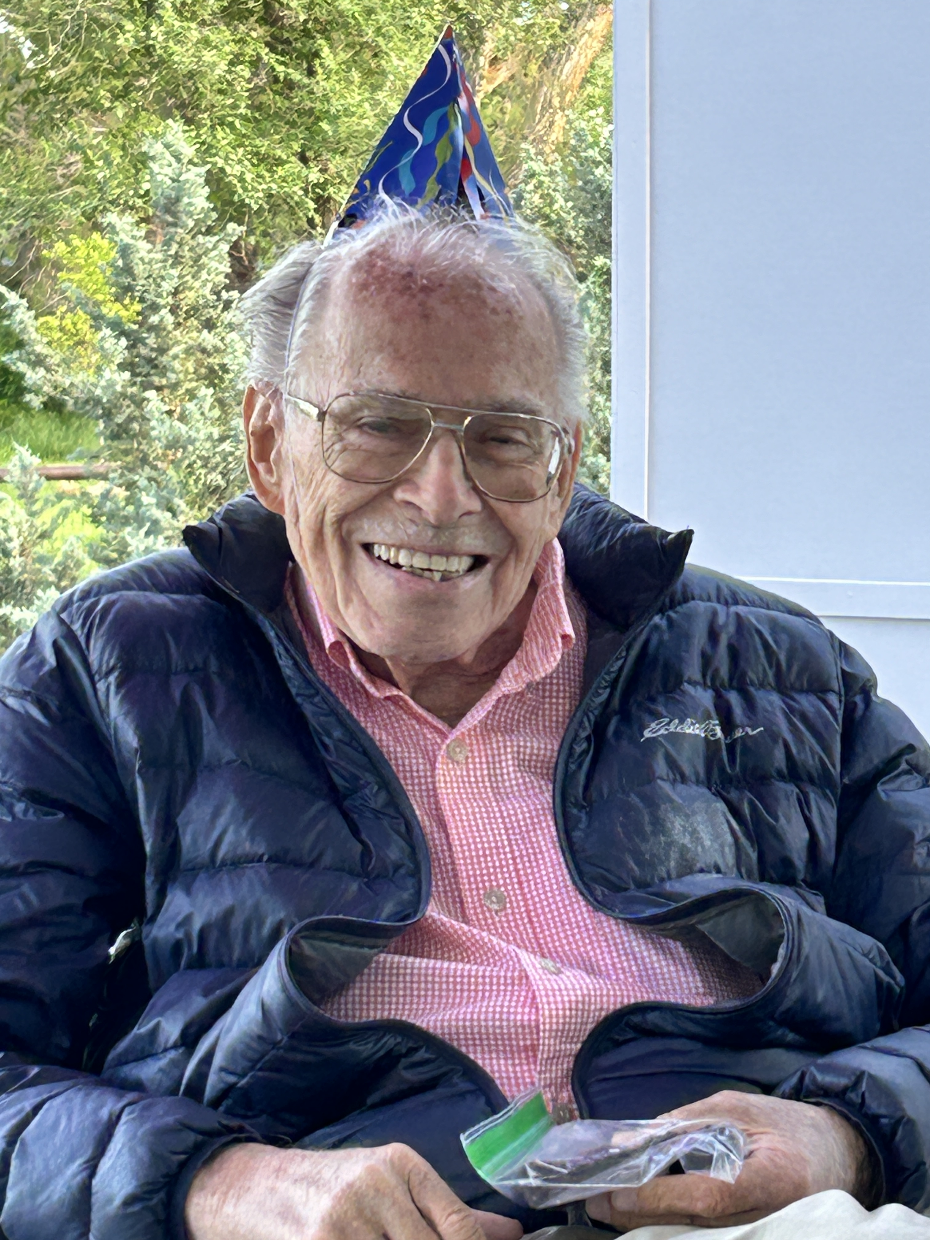
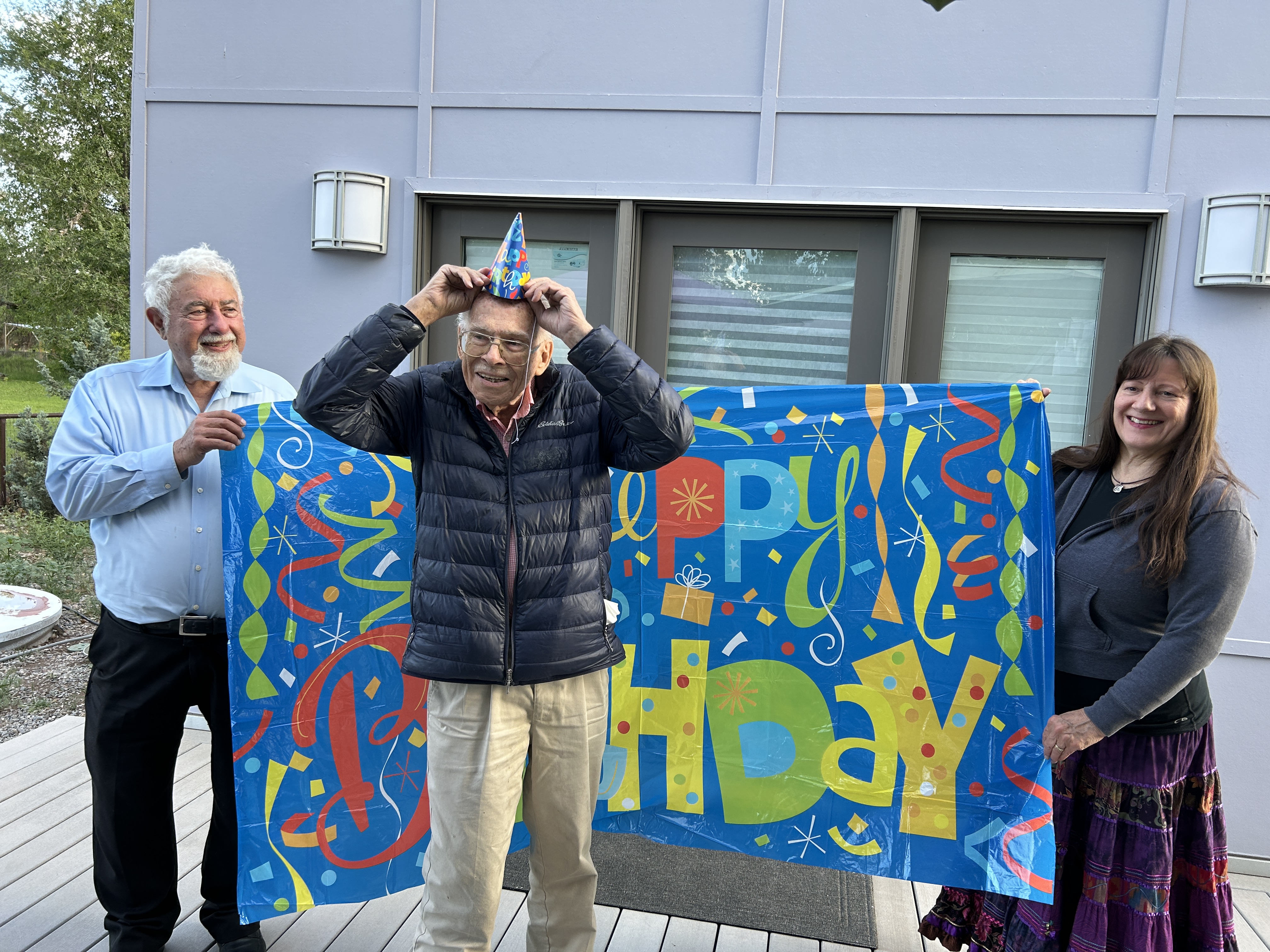
Memorial Weekend 2024 and the month of Jerry Widdison’s 90th Birthday
We drove on the old 66 highway in the trusty old Civic, past Red Ryder’s “Beavertown” location and past the old building that stretches along the bottom of the canyon where Glen Campbell once joined his Uncle Dick Bills playing and singing with the Sandia Mountain Boys. Jerry recalled the radio and TV show. Remember the KOB jingle that Glen sang?*
Riding down the trail to Albuquerque
Saddlebags all filled with beans and jerky
Heading for K Circle B
The TV Ranch for you and me
K Circle B in Albuquerque
You’d sing it in the car on long drives home in the un-air conditioned Plymouth station wagon. “The TV Ranch for you and me,” changed to “That’s the place for you and me.”
*A couple of TACA board members who’d never heard it were subjected to a rendition at a recent meeting.
Northward from the Village of Tijeras was our route. The first stop wasn’t far – the Ojito de San Antonio county open space. The parking area is behind the San Antonio Catholic Mission Church which sits on a portion of an ancient Pueblo ruin. Treasured water from springs flows through the secluded valley to the settlement below – on the other side of the fast four-lane. The speeding traffic adds a special frisson to our journey.
From the giant roundabout construction project at Sandia Crest Road we headed up into to the Cibola National Forest. It was still early when we pulled into the Doc Long Picnic area and quickly left, reminded it was busy Memorial Weekend. The crowded noisy parking area was nearly full.
The place was named for William Henry ‘Doc’ Long, who was a pathologist with the US Forest Service and had an experimental station and cabin there from 1910 into the thirties. Jerry noted the canyon here is called Tejano, probably for Long, who was from Texas.
Onward and upward, past the Sandia Peak Ski Area – closed. That’s a missed opportunity. We’d pay to ride the chairlift on a nice day like this. Skiing and development for winter sports began as soon as the first road was built in the twenties. The La Madera Winter Sports area opened in 1938 and replaced an even older winter recreation area at Tree Springs. This and other factoids from the wonderful rich and heavy tome published by the East Mountain Historical Society.
Portions of NM 165, the Sandia Loop, date from the twenties and it was likely a trail before that. It follows the creek that runs north called Las Huertas. According to Place Names of New Mexico, the book Jerry has contributed to, the upper portion of the creek was named Ellis for the family that homesteaded there. There was once an old two story cabin on a pond fed by springs at the Ellis place. Toured in the eighties, the cabin was spooky dark and low and full with books. The woods were full of bear and the pond was full of water. The cabin burned down decades ago.
The Civilian Conservation Corps did a lot of work on the roads, trails, and picnic areas on forest lands here. The Las Huertas picnic area is one wonderful result. At a quiet a picnic table surrounded by beautiful huge ponderosas we had our lunch of chicken sandwiches and ginger beer.
The trusty Civic made it through the mountain on rocky rough NM 165 down to Placitas. On a whim we went north where the paved road bends west into the village. There are new big houses all over these hills now. They’re a stark contrast to what some people had going out here 50 or 60 years ago. Jerry remembers the commune named “Tawapa” and it’s in the Place Names book. There were several others, most short-lived.
The Tawapa residents were displaced after losing a court battle over ownership in the 1980’s. It echoed the fate of a place called Tejon near here. The Tejon Land Grant was purchased and its residents displaced after losing a legal fight in 1890. It’s always been about land. And water.
Las Huertas Creek is named for the vegetable and fruit gardens and the meager flow is precious here.
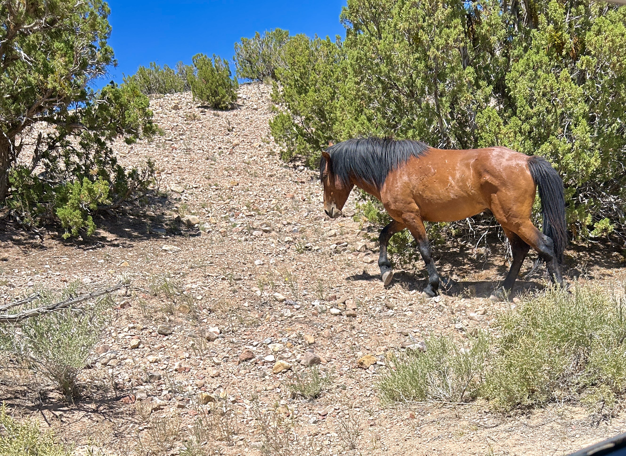
We came upon a feral horse herd. It felt like a magical equine safari. Chirrups at a bay stallion from the open window failed to even cause an ear to twitch. He didn’t give us the time of day. But it was about 3PM.
We completed the Sandia Loop Road, and headed down the trail to Albuquerque in the trusty dusty Civic, thoroughly enchanted.
Jerry Widdison had his 90th and celebrated in May at a surprise birthday party and again at the May TACA board meeting. Here’s background on Jerry from a previous post.


